
Traveling around the Dominican Republic can easily become part of your vacation, but it’s not like driving in the continental U.S. or Europe. Distances aren’t huge, but travel times often take longer than expected due to road conditions, traffic patterns, and local driving culture.
This guide gives you a practical “text map” of the most common routes tourists use — with approximate distances and real-world travel times.
Why Travel Times Matter in the Dominican Republic
Unlike flat grid highway systems, the Dominican Republic has:
- A mix of modern highways and slower secondary roads
- Mountainous interior terrain
- Traffic congestion near cities
- Speed bumps and unmarked obstacles
- Limited signage outside main routes
So a short distance doesn’t always mean a short drive.
Distances & Travel Times — Key Tourist Routes
Here’s a quick reference for planned travel and day-trip planning:
Cancun ⇢ Santo Domingo
(For perspective — flights, not drives)
Not drivable — flying is the only option.
1) Punta Cana ⇢ Bávaro
- Distance: ~10–15 km
- Typical Drive Time: 15–25 minutes
- Notes: Very short, served by main highways and easy transfers.
2) Punta Cana ⇢ Santo Domingo (Capital)
- Distance: ~200–220 km
- Typical Drive Time: 2.5–4 hours
- Best Route: Autopista del Coral / DR-3
- Tip: Early starts avoid traffic near Santo Domingo.
3) Punta Cana ⇢ La Romana
- Distance: ~80–90 km
- Typical Drive Time: 1.25–1.75 hours
- Notes: Well-used route; good condition roads.
4) Punta Cana ⇢ Bayahibe
- Distance: ~75–85 km
- Typical Drive Time: 1.25–1.75 hours
- Notes: South-coast route, often used for Saona Island tours.
5) Punta Cana ⇢ Samaná
- Distance: ~300–340 km
- Typical Drive Time: 5.5–7.5 hours
- Notes: Long drive — better as an organized tour with stops.
6) Punta Cana ⇢ Puerto Plata
- Distance: ~360–410 km
- Typical Drive Time: 6–8 hours
- Notes: Long cross-island drive; consider splitting into stages.
7) Santo Domingo ⇢ Puerto Plata
- Distance: ~210–230 km
- Typical Drive Time: 3.5–5 hours
- Notes: Major inter-city route.
8) Santo Domingo ⇢ Samaná
- Distance: ~180–220 km
- Typical Drive Time: 3.5–5 hours
- Notes: Important tourism corridor.
9) Santo Domingo ⇢ La Romana / Bayahibe
- Distance: ~90–120 km
- Typical Drive Time: 1.75–2.5 hours
- Notes: Often used for day trips to Saona departures.
10) La Romana ⇢ Bayahibe
- Distance: ~25–35 km
- Typical Drive Time: 30–45 minutes
- Notes: Quick and easy coastal connection.
Understanding the Variability
Why Times Fluctuate
- Traffic near cities — Santo Domingo and Punta Cana area can slow down dramatically during rush hour
- Road type — highways are faster than rural 2-lane roads
- Weather — heavy rain can reduce speeds
- Speed bumps (topes) — frequent near towns
- Local driving styles — expect overtaking and irregular lane usage
Planning Tips
📌 Start early when crossing long distances
📌 Build buffer time — +30–60 minutes beyond GPS estimates
📌 Avoid night driving unless necessary
📌 Use private drivers or tours for long crossings
Comparing Modes of Transport
| Route | By Car | By Private Driver | By Shuttle / Bus |
|---|---|---|---|
| Punta Cana ⇢ Santo Domingo | ~3–4 hrs | Same | + more time |
| Punta Cana ⇢ Bayahibe | ~1.5–2 hrs | Same | Same |
| Santo Domingo ⇢ Samaná | ~4–5 hrs | Same | Longer |
| Bayahibe ⇢ Saona Island (boat) | — | Transfer + boat | Same |
Managed Transfers vs Driving Yourself
Pros of private drivers / tours
✅ No navigation stress
✅ Local road familiarity
✅ Breaks planned
✅ Often cheaper than rental car + insurance
✅ Safer for tourists
Cons of self-drive
⚠ Road signs vary
⚠ Insurance costs high
⚠ Parking challenges in cities
⚠ Stressful traffic situations
Most visitors find private transport or organized tours more efficient, unless you’re experienced with local driving.
Example Travel Plans With Times
Day Trip: Punta Cana ⇢ Bayahibe ⇢ Saona Island
- Drive: ~1.5 hrs one way
- Boat tour: ~6–8 hrs
- Return: ~1.5 hrs
Full day: 10–12 hrs total travel + activity
Weekend Trip: Punta Cana ⇢ Santo Domingo
- Departure: ~7:00 AM
- Arrival: ~10:30 AM
- Sightseeing: 6–8 hrs
- Return next day
Overnight: Punta Cana ⇢ Samaná
- Long drive, better as 1–2 day itinerary
- Stops along the way recommended
Tools That Help You Plan Times
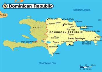
While I can’t give you a visual map here, the following tools are extremely useful for planning:
🗺 Google Maps — shows real-time traffic and alternative routes
🚘 Waze — live local traffic reporting
📱 Local drivers / tour operators — reliable time estimates
Tip: Distances are predictable; times are variable.
FAQ – Distances & Drive Times in the Dominican Republic
Is a 3-hour drive the same as in the US?
Not always — expect slower averages on secondary roads.
Is public transport faster?
No — buses and guaguas take longer and stop frequently.
Are highways good?
Main highways (DR-1, DR-3) are decent, but local roads vary.
Is it better to fly between distant regions?
Sometimes — flights exist between Santo Domingo and Samaná or Punta Cana.
Final Notes — Mapping Your Trip Without a Visual Map
You don’t need a map image to travel smart — just:
✔ Know your major routes
✔ Understand real travel times
✔ Use local expertise where needed
✔ Build buffers into your plans
The Dominican Republic is easy to explore when you plan for distance plus time reality, not just distance on paper.